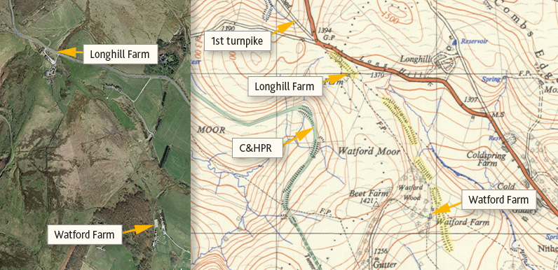
Above: I’ve highlighted the earthworks in yellow on this map from the 1950s. And the C&HPR line in green
Watford Farm lies on a popular walk into the Goyt Valley from Buxton (walk 21). On the right, as you approach the farmhouse from Cavendish Golf Course, is a hard-standing area used to store heavy machinery. And on the left is a flat area of grassland that looks like it must have been formed for some purpose in the past.
This is the southern end of an earthwork that stretches for around a mile. The northern end is at Longhill Farm, which lies near the lane running down into the Goyt Valley from the Long Hill Road between Whaley Bridge and Buxton.

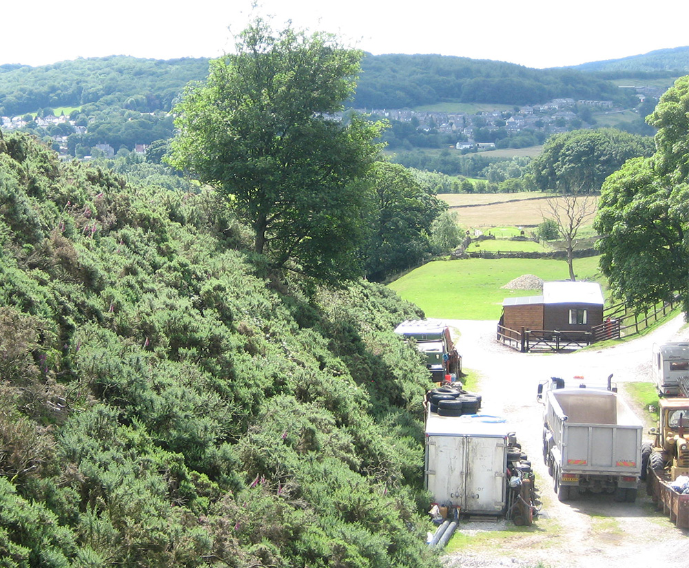
Above: The view from above Watford Farm, looking south along the final section of the embankment (photo: Alan Roberts).
There are conflicting ideas about what purpose the embankment may have served. And the various theories have surfaced again on the Goyt Valley Facebook Group.
Some say it was created around 1840s to install a large military gun, maybe as part of a military training exercise. Andrew has excavated here in the past and discovered many military artefacts from this period. (We know it was used during WW1 to train soldiers in trench warfare – click for details.)
Others suggest that it could have been dug during the construction of the first turnpike between Whaley Bridge and Buxton, opened in 1795. It certainly connects – and in the same direction. Maybe it was simply abandoned when a better route was found.
But the most popular theory is that it’s associated with the nearby Cromford & High Peak Railway that ran through the Valley from 1831, and could have been used as a test track. Robert sent a comment:
I think that this is a short piece of railway built to demonstrate ‘Fell’s Experimental Railway’. I seem to remember an article in the Railway Magazine in the 1950s about it. It ran underneath the Cromford and High Peak in a sort of S curve. Fell had the idea of two horizontal wheels compressing against a central rail in order to get up steep gradients.
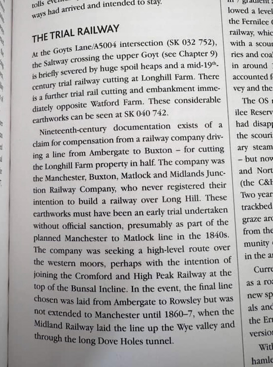
Andy has managed to discover the only written evidence we have – about a legal claim from Longhill Farm against a railway company for cutting their land in half. But it’s not the C&HPR.
The report explains that this company (later to become Midland Railway) was seeking a route for the extension of their Matlock to Buxton line into Manchester in the 1840s. The plan may have been to join the C&HPR at the top of the Bunsal Incline. But the company was forced to abandon these plans for another route.
My go-to guru for the history of local transport information is Alan Roberts, who has written books on both the turnpikes and the railways, and also hosts presentations on the subjects. He explained:
I have been looking for information on them for years. Originally, I thought that they were part of a plan to build a branch of the Leek/Buxton Turnpike to provide a link to the Grin Low quarry area, to save packhorses going too near Buxton.
Then, I was shown the short article (above) which comes from a walking guide. I contacted the author to try and find the material that he quoted but he couldn’t remember the source. I couldn’t find anything in the railway company’s records.
However, a possible interpretation comes from the fact that the LNWR was running CHPR in the 1870s and was making some upgrades at that time. One such upgrade was to replace the Hopton Incline with a 1 in 15 stretch of adhesion railway, no winding gear.
This proved unsuccessful because at times it took two locos to get freight wagons up the slope and it didn’t operate in bad weather. The Watford Incline has a 1 in 15 slope so it could have been part of an upgrade plan to get a better line to Whaley Bridge. Then the complaint from Long Hill Farm blocked it.
Then, along comes this folk memory of moving a large gun up a slope built for military purposes. I did wonder if it could have been part of some extensive military training exercise, I can’t think why else they should be dragging a big gun about in that area.
However, the railway option still strikes me as the most likely though where the line would have gone beyond Long Hill is anybody’s guess – perhaps to follow the general line of the road to Whaley Bridge.
Perhaps, buried away in the LNWR archives is a clue but I am not going there!
I’ll try and get in touch with Longhill Farm to see if they have any more information about the legal claim and will update this page if I discover more. Meanwhile, if anyone can shed some light on the mysterious earthworks, or wants to support any particular theory, please leave a comment below, or head over to the Facebook Group.


David has written an excellent summary on the here and it would be good to get to the bottom of this little mystery. Sadly, I lost touch with John Leach a long time ago and my friend Oliver who regularly corresponded with him has sadly passed away. I know Oliver also had information about these features.
Personally, I think this is a railway embankment for several reasons:
I’m reasonably familiar with railway engineering and this stands out to me as a railway feature , that lower down the hill is built to double track mainline standard. David’s image in the article illustrates the enormous scale of the earthworks at this point and if correct, this would mean it dates to a point in time later than the Cromford and High Peak railway nearby.
We have the documentary evidence relating to railway construction referenced in the extract above and also by John Leach, who states that he has seen it and it’s in the possession of the farmer, or was at the time of writing.
So where does the anecdote of the gun come in? I haven’t been to the site in years and so this is a guess, but I understand from other contributors that military training took place around WW1 and several trial trenches were built. It is not inconceivable to me that part of this would involve movement of guns in challenging conditions, as would be found at the front? That would account for this anecdote as the locals would have watched it being built.
Andrew references a lot of archaeological finds that provide substantial further information. The archaeological context of these finds is missing from my knowledge which is vital in interpreting this site. However, there are lots of glass and other finds that Andrew states date from the 1840s or later. They could have been used by troops or they could equally have been used by navvies building the railway. The military finds are very interesting, but I’m not clear on the date. Are the military finds dateable and if so,to what period do they date? Were they found in the same layer as the glass finds and the same location?
I personally think then we have both uses here – an early trial railway, especially further down toward Watford Farm, and a period of military use that came later and is reflected in trial earthworks at the top of the hill. Only a proper survey and site visit is likely to get to the bottom of it.
I’ve also got maps of proposed railway deviations that never happened somewhere, but I suspect they are later in time than this feature. I’ll look them out and see if they shed any further light, however they are mainly concerned with proposed deviations around Buxton to the North and South.
I occasionally dip into this fascinating website to see what is “new” to the already comprehensive historical information regarding the Goyt Valley and its surroundings. I was particularly intrigued about the theories put forward regarding the earthworks between the farms of Longhill and Watford.
One of my ‘go to’ map resources these days (and I speak as a former Ordnance Surveyor) is the National Library of Scotland Maps website. This free to use website has some of the most comprehensive on-line mapping tools you could wish for, with unrestricted access to UK OS maps of all types and scales dating back to the late 1800’s. Of particular interest when researching is the large scale OS maps publish in the late 19th and early 20th centuries, notably the 6-inch and 25-inches (to the mile) detail plans.
The NLS tools allow for side-by-side map comparison (the most useful) or the overlaying of two different map types including satellite imagery, such that it is possible to directly compare old features (which, at the time of their original mapping are less likely to have been disturbed by large scale developments such as extensive quarrying etc.) with much later and more up-to-date 21stC mapping.
One of the more recent additions to the NLS library is LIDAR digital terrain modelling and this can be used to great effect in conjunction with turn of the 19th century maps when comparing ground terrain with modern map features.
By selecting the NLS side-by-side map option it is possible to view the six-inch edition of the area to which this “Mystery Earthworks” article refers on one side of the screen with the LIDAR DTM 50cm-1m imagery on the other. The effect of comparing of these two map types is startling as two dimensional map features suddenly reveal themselves in virtual three dimensional detail. (Click to view.)
By using the map tools it is possible to trace features on the LIDAR map against an image of the turn of the 20th century map. In this instance it is clear that the curving feature of the earthworks on the LIDAR map (which can be picked out very easily) follow the (indistinct) line of embankments and cuttings drawn on the 6-inch map.
Where these Mysterious Earthworks meet the current A5004 Long Hill Road to the north of Longhhill Farm it seems almost certain from the LIDAR image that the line of travel is a probable continuation of the Old Longhill Road, the middle “prong” of the three obvious routes emanating west and north from this point.
Similarly at the Watford Farm end it would appear that the earthworks come to an abrupt termination with no further sign of any form of groundworks having taken place to the south. Even the cutting at the northern end of this section appears to be an abandoned section of earthworks. It is unlikely that a tunnel would have been planned here but it would appear to be an area where a section of cut and fill has taken place, i.e. the material being cut from the rising ground to the north is used to form an embankment at the southern end of the works.
Zooming the map(s) out it appears likely that this may have been an earlier turnpike route towards Buxton but was abandoned when a more obvious and better graded route into Buxton via Longhill and Coldspring Plantation became apparent. Certainly to continue the earthworks southwards from Watford Farm towards Buxton via a crossing of the River Wye would have almost certainly presented a much more challenging set civil engineering works than the current (modern) road alignment into and out of Buxton.
I think that this is a short piece of railway built to demonstrate “Fell’s Experimental Railway”. I seem to remember an article in the Railway Magazine in the 1950s about it. It ran underneath the Cromford and High Peak in a sort of S curve. Fell had the idea of two horizontal wheels compressing against a central rail in order to get up steep gradients.
If you don’t already know of it, this web site might help. The Railway Magazine article from 1961 I remember, even now, as being very interesting. I think it gives more detail than the DCC note but I read it a long time ago. There should be a copy in the railway special collection -if it still exists- in Stockport Library.
Have you any information about Wainstones on the old road between Whaley Bridge and Buxton? I am researching round-shafted crosses in the area and think there may have been two at this site. Was the name once Twainstones?