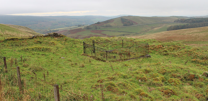
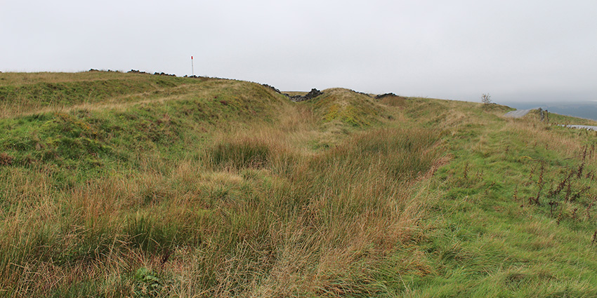
Above; Don asks whether anyone knows what might once have been here, at the junction of the Long Hill road and Goyt’s Lane.
I’ve recently moved back to Buxton, which is the reason for the recent flurry of posts as I try to catch up with all the projects I’ve been wanting to tackle. My wife thinks I’m getting a touch of OCD about the valley. And she may well be right.
But it makes the effort worthwhile when people get in touch who share an interest in the social and industrial history of the area. Don recently sent me this message…
Thank you for your enthusiasm for ‘our valley’. As you turn off Long Hill near the cattle grid, do you know what the iron railings and what looks like foundations of buildings were, over the wall near the old packhorse lane?
I believe also, on your left, the ruts that follow the road down to Errwood are old packhorse tracks which, when they got to worn, people just moved across to create a new track.
My initial thought was that it may have been a toll house since it seems an unlikely place for any kind of dwelling. But I don’t have a wonderful record when it comes to guesswork. So any ideas or suggestions would be very welcome.
Ancient ‘holloways’
Don also mentions the remains of old packhorse routes on the opposite side of Goyt’s Lane (above). Known as ‘holloways’, they’re clearly visible on the satellite image. They cross over the Long Hill road, merging into the landscape a short distance further.
There’s some excellent information on the history of local roads, tracks and trails – including those through the Goyt Valley – on the Whaley Bridge Local History website: see Part 1 & Part 2. Here’s an extract about the tracks Don mentions;
Holloways are formed by countless travellers wearing down the soft peat causing deep hollows, when they became to difficult to pass they just moved sideways on a new pathway.
You may have driven past many times and never noticed one of the best examples, next time you cross the top of long hill stop where you turn to Errwood and look both sides of the road those deep furrows are not naturally occuring.
You can trace them all the way down toward The Goyt to Cromford High Peak railway / Sandy Lane, likewise they can be seen heading for Buxton in the fields top side of Long Hill until you get to ground that has been ploughed.


David, re. “Long Hill mystery”: Could the fenced off area just be a sheep or cattle pen?
Could it have housed a set of meteorological instruments? There used to be some, or maybe they are still there, at the top of The Slopes across the road from the Buxton Museum.
I’ve read somewhere that this was the site of the first Long Hill Farm. It adjuncts the two ancient trade/Roman routes coming up out of Buxton, and coming across the edge of Combs Moss, which lead down that lane to the bottom, bears left down the cleft of the hill, emerging at what’s now the bottom of Bunsal Cobb. Waymarker stones indicate the route.
Maybe that well, which was in the centre of the house, dried up, and that’s what the metal railings are protecting. I don’t know the reason for the farm going out of use… maybe the severely exposed location made it untenable, so they moved it to 100 yards behind, which is more nestled under a slight hillside.
There were two farms – one called Long Hill Farm the other House Farm (or Top Long Hill Farm as I know it). Both were occupied in 1861 by members of the Hibbert Family. Long Hill Farm was Mary Hibbert, age 60, farmer of 104 acres, born in Fairfield. House Farm was Thomas Hibbert, age 71, farmer of 150 acres, born Fernilee. The census is complicated around the Goyt valley as a number of registration districts meet two counties. Long Hill Farm is in The Upper Hartington Quarter (District 5 in 1861, District 7 in 1891) which covers most of Burbage and Axe Edge and Goyts Moss Farm at the other end of the district.
It’s marked on a later map as a rain gauge. There is another mystery though; down towards Buxton – around Watford Farm – is something that look like a section of railway embankment. No railway marked on any maps, and I’m not aware there was ever a railway up the valley. I wonder what that is all about…
The railings protected the rainfall and other gauges; it was checked every day by water board officials who worked down at the filter station. The last man to check it as far as I know was Harold Smith. There were two others as well in the valley that were also regularly checked. A few years ago I was driving up Long Hill and glanced over at the weather station and was horrified that some idiot had caught a sheep and had managed to throw it over the railings. Its lamb was outside crying for its mother. I managed to free the ewe so she was reunited with her lamb.
Re the apparent embankment at Watford Farm mentioned by Andrew Foster above, in the Derbyshire County Council Monument Records (number MDR14096: Linear Earthwork South East of Watford Wood, Buxton), it suggests it is a “trial” railway cutting and embankment. Grid ref is. SK 0402 7410
Excerpt follows: A linear, slightly curving earthwork is marked on the 1st edition 25″ OS map of c. 1880. It comprises a cutting at its northern end and an embankment at its southern end. (1) The earthwork is still visible on modern OS maps and aerial photographs. The southern tip runs in to what is now Cavendish Golf Course. The northern end is covered in scrub. (2-3) The earthwork appears much like a railway cutting and embankment. It seems likely that it relates to the unfinished railway cutting and embankments further to the northwest [see SMR 31695]. There is evidence to suggest that this railway cutting may have been an early trial carried out without official sanction, with the final line being laid elsewhere. (4)
There have been quite a few comments on the Goyt Valley Facebook Group about this topic. Click to view.