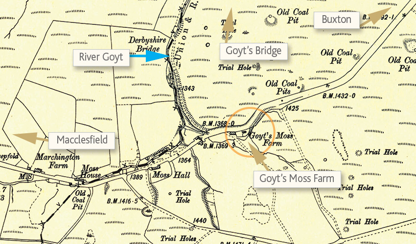
Above: This 1890 OS map (click to enlarge) shows the four buildings along this short stretch of the old Macclesfield to Buxton road, as well as the many small coal pits and trail holes which once pitted the landscape.
The Cat & Fiddle pub is a short distance to the left. The road to Goyt’s Bridge runs north alongside the River Goyt (which is very much a stream at this point).
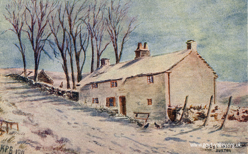
Above: A similar painting to the one at the top of the page, and by the same artist, but in the depths of winter (click to enlarge). Click here for more info on Goyts Moss Farm.
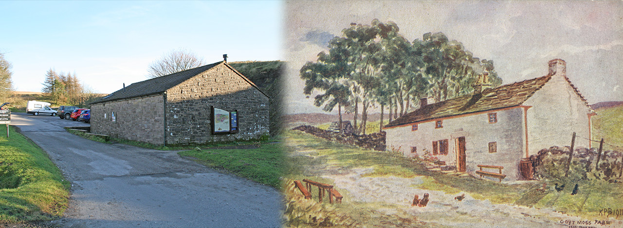
Above: Goyt’s Moss Farm was a white-washed, stone-built farmhouse lying beside the Macclesfield to Buxton road. It’s been completely rebuilt (I’m not sure when) and now functions as a Peak District National Park Rangers information centre and toilets, lying beside the small car park at Derbyshire Bridge. (Page update: Click here to see that I got that wrong!)
Gotys Moss Farm
Goyt’s Moss Farm was one of four houses lying within a quarter mile stretch of this once busy road (see below), just down from the famous Cat & Fiddle pub. There are very few traces of the other three buildings beyond some scattered dressed stones slowly disappearing beneath the moorland vegetation.
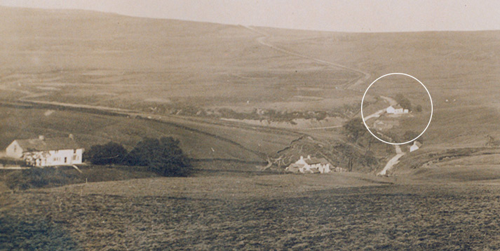
Above: This photo shows the four houses in Goyt’s Moss. I’ve circled Goyt’s Moss Farm. The old Macclesfield to Buxton road vanishes over the horizon. And the narrow lane to Goyt’s Bridge goes to the left.
The Macclesfield to Buxton road was diverted sometime around the 1930s. The old road now provides a great route for walkers across the open moorland. (See walk 11.)
Goyt’s Moss is surrounded by small coal pits which would have provided both fuel and income to the families who lived in this exposed and fairly remote moorland landscape.
My thanks to Mike for providing the census records below. I think some of them may be for Moss House, which was the next door property. I’ll update this page if things become any clearer.
Page updates
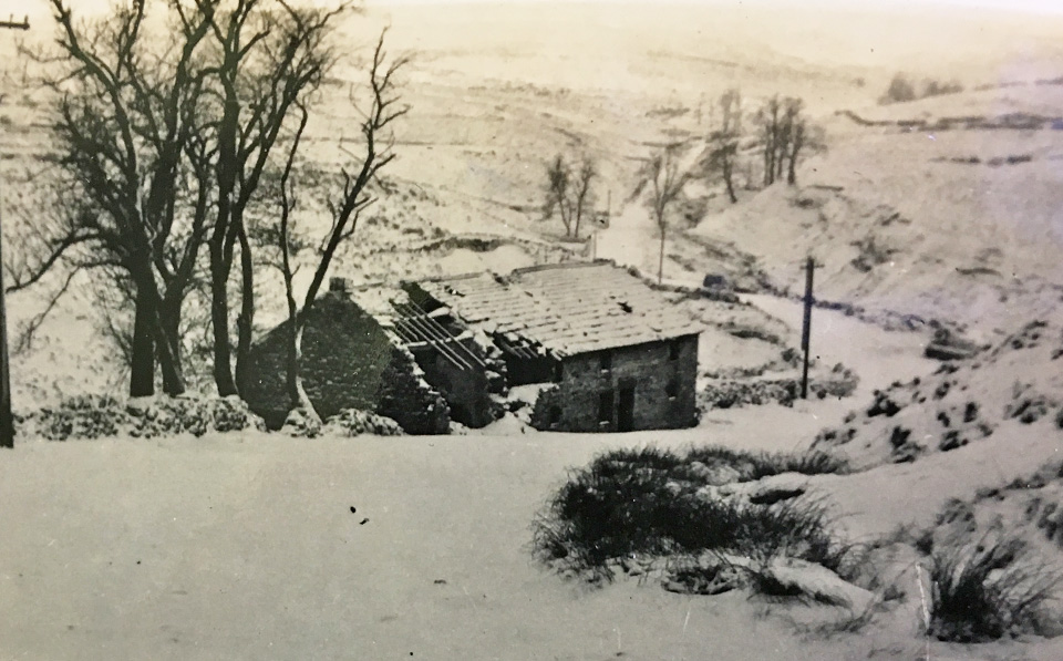
I found this photo of the ruins of Goyt’s Moss Farmhouse in the snow in an old photo album from the 1960s kept in Matlock Public Records Office. I’d always thought it would have been demolished in the 1930s, along with all the other farmhouses on the Errwood Estate. But perhaps that wasn’t the case. There are certainly no signs of Moss Hall which would have been visible in the distance, on the same side of the road.
The text at the bottom of the page mentions that the house was used by shooting parties. Perhaps that’s the reason it survived longer than other buildings.
Click here to view a ‘then & now’ fade which shows that I wasn’t right in thinking today’s Rangers’ cabin was built on the same spot as the farm.
The text below comes from some papers stored in the Derbyshire Bridge Rangers Hut.
Goyt’s Moss Farm (J. Lomas lived here 1917-1928)
The farm was 110 acres and extended along the south side of the old road to Burbage, up to the ridge of ‘Girding Hill’, a large pasture which was grazed by cattle.
Snipe were common on the wet, flatter areas. Curlew were mainly on the edge of the ridge where the vegetation was cotton grass. There used to be a two-line telephone overhead cable along the old Burbage road, and red grouse were regularly found dead under the wires by Jim Lomas, quite often an average of two per week in the late summer after young birds were on the wing. Later, corks were put on the wires after complaints from the gamekeeper (Perks).
An extensive moorland fire burned 6″ – 9″ of peat on Diamond Hill area. It was started by a picnic fire somewhere near the Goyt stream and spread right up the moor, lasting for three weeks. It was controlled by the Berryclough stream, using water from the stream, and here there was less depth of peat. In the seasons following the fire, young heather did re-colonise the area but did not produce such good growths as other parts of the moor. Bracken grew more easily after the fire.
The shooting cabin was abandoned when Boothman’s Cottages were vacated, and shooting parties made use of the house as an alternative. The Lomas family moved to Kettleshulme in 1928 when Stockport Corporation acquired the valley for reservoir construction.
| Surname | First name | Born | Relationship | Occupation | Birth place |
|---|---|---|---|---|---|
| 1841 Census (Goits Moss) | |||||
| Shufflebottom | John | c1791 | Head | Stone mason | |
| Shufflebottom | Sarah | c1791 | Wife | ||
| Mycock | Jane | c1811 | Servant | ||
| 1851 Census (Goyts Moss) | |||||
| Ward | David | c1800 | Head | Banksman | Macclesfield Forest |
| Ward | Ann | c1813 | Wife | Flagg | |
| Ward | John | c1836 | Son | Works on land | Goites Moss |
| Ward | Hannah | c1838 | Daughter | Goites Moss | |
| Ward | Sarah | c1841 | Daughetr | Goites Moss | |
| Ward | David | c1812 | Son | Goites Moss | |
| Mycock | Fanny | c1830 | General servant | Flagg | |
| Wilshaw | Joeseph | c1816 | Agric. labourer | Goites Moss | |
| 1861 Census (Goites Moss) | |||||
| Wards | David | c1819 | Head | Farmer of 70 acres | Macclesfield |
| Wards | Ann | c1813 | Wife | Derbyshire | |
| Wards | Sarah | c1859 | Daughter | Goits Moss | |
| Wards | Joeseph | c1852 | Daughter | Goits Moss | |
| Moss | Martha | c1847 | Servant | Chesterfield | |
| Johnson | William | c1816 | Servant | Macclesfield Forest | |
| 1861 Census (Goits Moss Cottage) | |||||
| Ward | Hannah | c1874 | Head | Macclesfield Forest | |
| Ward | James (?) | c1844 | Bollington | ||
| 1871 Census (Goyts Moss) | |||||
| Austin | William | Head | Labourer | Caulden | |
| Austin | Mary | Wife | Mayfield | ||
| 1881 census (Goyts Moss) | |||||
| Ward | John | c1838 | Head | No occupation | Goyts Moss |
| Ward | Sarah | c1839 | Wife | Fairfield | |
| Ward | Fanny | c1875 | Daughter | Goyts Moss | |
| Ward | Martha | c1878 | Daughter | Goyts Moss | |
| 1891 Census | |||||
| Keeling | John | c1847 | Head | Farmer | Kingsley |
| Keeling | Jane | c1856 | Wife | Staffordshire | |
| Keeling | Ellen | c1878 | Daughter | Harpur Hill | |
| Keeling | Elizabeth | c1880 | Daughter | Harpur Hill | |
| Keeling | Thomas | c1884 | Son | Harpur Hill | |
| Keeling | Mary | c1888 | Daughter | Harpur Hill | |
| Newton | Sarah Elizabeth | c1887 | Neice | Flash | |
| 1901 Census | |||||
| Palfreyman | Mary | c1836 | Head | Farmer | Staffordshire |
| Kidd | Sarah Annie | c1880 | Daughter | Staffordshire | |
| Goodwin | Sarah Ellen | c1888 | Granddaughter | ||
| Ford | John | c1884 | Servant | Farm servant | Chapel en le Frith |
| Keeling | John | c1850 | Head | Farmer | Kingsley |
| Keeling | Jane | c1855 | Wife | Staffordshire | |
| Keeling | Ellen | c1878 | Daughter | Harpur Hill | |
| Keeling | Thomas | c1884 | Son | Derbyshire | |
| Keeling | Mary | c1888 | Daughter | Derbyshire | |
| Keeling | Jane | c1892 | Daughter | Goyts Moss | |
| Keeling | Charlotte | c1895 | Daughter | Goyts Moss | |
| Keeling | Ernest | c1898 | Son | Goyts Moss | |
| Keeling | John | c1900 | Son | Goyts Moss | |
| 1911 Census | |||||
| Keeling | John | c1847 | Head | Farmer | Kingsley |
| Keeling | Jane | c1856 | Wife | Quarnford | |
| Keeling | Thomas | c1884 | Son | Working on farm | Harpur Hill |
| Keeling | Mary | c1888 | Daughter | Dairy work | Harpur Hill |
| Keeling | Jane | c1892 | Daughter | Dairy work | Goyts Moss |
| Keeling | Charlotte | c1894 | Daughter | Dairy work | Goyts Moss |
| Keeling | Ernest | c1898 | Son | Goyts Moss | |
| Keeling | John | c1900 | Son | Goyts Moss | |
| Phillips | Helen | c1878 | Daughter | Harpur Hill | |
| Phillips | James A | c1876 | Son in law | Grocer | Cleveland |
| Barber | Walter Henry | c1886 | Visitor | Chauffer | Cheadle Hulme |
