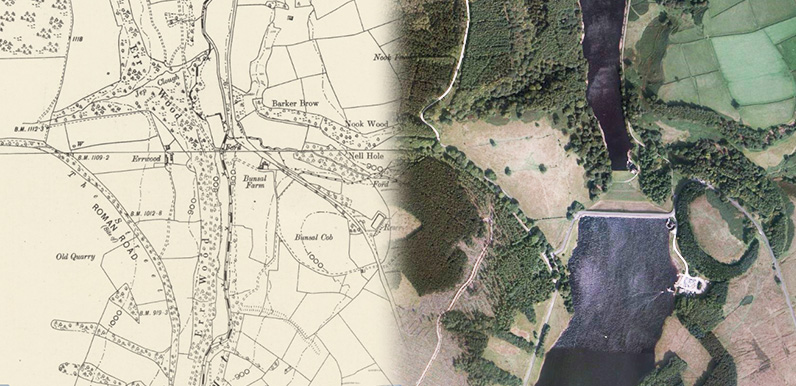
Above: There’s quite a change from the 1888 map on the left and a satellite image today.
Fernilee Reservoir to the north was opened in 1937. Work on Errwood Reservoir was postponed because of the war. And was eventually declared open in 1968.
The main route into the valley – the Bunsall Incline – comes in from bottom right. Errwood Sailing Club is on the right bank of Errwood Reservoir. And the main car park, hidden by the trees, directly opposite.
I have to admit that I’m going through a bit of a phase. And it’s turned into an obsession. Which is a little sad at my time of life. But hey ho; I need some form of distraction from the depressing election, which is less than a week away!
I’m talking about fades. The ‘then & now’ images which transition between old and new. I first created them for another website more than 10 years ago.
The Museum of Scotland’s magical website, showing exact matches between old Victorian maps and modern-day satellite images, provides perfect images for these fades. (Click for more information.)
It has enabled me to accurately plot features of the Goyt Valley landscape which vanished with the construction of the twin reservoirs; Fernilee in the 1930s, and Errwood in the ’60s.
I’ve just completed a series of fades of the lower Goyt Valley – following the river all the way from Goyt’s Moss (Derbyshire Bridge) in the south to Taxal in the north.
The images pass through the Errwood Estate, which was purchased by Stockport Corporation for the construction of the reservoirs, following the death of the last Grimshawe of Errwood Hall in 1930.
Above: This is the section running north from Goyt’s Bridge. Click the ‘Now’ button – or drag the green slider – to see the same view today, dominated by Errwood Reservoir. Click the link below to view the key to the numbers on the map.