The OS co-ordinates are 005752. Any ideas on what they might once have been would be much appreciated.
Mystery no.1
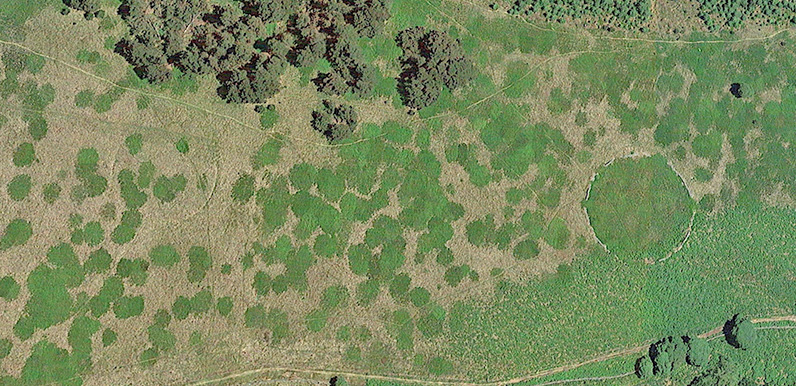
As I was creating the ‘fly-thru‘ of the Foxlow Edge walk, I noticed a couple of circles high on the ridge captured by Google’s satellite camera.
To my untrained eye, they look like the remains of stone age huts. But as anyone who follows this blog will know, most of my guesses soon get shot down in flames.
So I decided to get in touch with the experts to see if they had any records showing what they might be. Anna Badcock is Cultural Heritage Team Manager at the Peak District National Park Authority.
Anna said they have no records of the circles. But since one of them is bordered by the remains of a stone wall, it’s likely the the fainter circle would also have been surrounded by a wall. And that they’re most probably enclosures of some kind.
Anna also thought they could have been part of the designed landscape around Erwood Hall. But said it would need a field visit to confirm things.
My initial reaction was that they look too neatly circular to be simple field enclosures. And it seems odd to have two so close to each other, one of which has virtually vanished from the landscape. But I’ll follow Anna’s suggestion and take a closer look.
Buxton Museum has been displaying a fascinating exhibition called ‘Lullaby of the Larks‘ which commemorates a massacre at a nearby Iron Age hill fort called Fin Cop, some 15 miles from the Goyt Valley.
Our stone-age ancestors always seem to have settled on high ground, in locations with good all-round visibility to quickly spot any potential threats. And Foxlow Edge certainly fits the bill. So until someone proves otherwise, I’ll continue to hope this is what the circles must be.
Page update: Anna pointed out that, although she hasn’t measured the circles, she feels they would be too large for huts. And looking at the nearby trees to get an idea of scale, I’m sure she’s right. So another of my theories bites the dust! But I still think they look an unlikely spot for field enclosures.
Mystery no.2
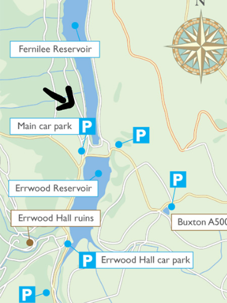
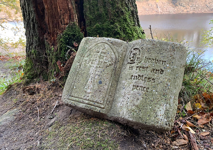
Jessica got in touch to ask about a stone book she and her boyfriend found near the top end of Fernilee Reservoir, placed at the base of a tree:
…at the start of the path was a stone book, with the words ‘In Heaven is rest and endless peace’ carved into it. It looked fairly old, as the words were slightly worn. I had a look on your website and I couldn’t find any mention of it. Do you know the story behind this?
I must have gone past this spot many times, but have never noticed it. From the ground around it, it looks as though it may have been placed here fairly recently. I’m wondering whether it may have been part of a graveyard memorial. But who knows?
Jessica sent a map showing its approximate position. Any ideas would be much appreciated. Simply leave a comment below, or send me message.
Regarding mystery number 1 – the circular enclosure which is still very visible is something I have also often wondered about. I have looked at ordnance survey maps from the era of the hall, and it is shown as a walled enclosure on those maps, but the other one is not shown at all, so I assume they are not part of the landscaping associated with the hall.
I have wondered whether the wall enclosed something which sheep needed to be kept away from for some reason, as I have seen similar walls in fields encircling a group of trees, though there are no trees shown within the wall in this place on the old maps.
That said, there is another, smaller, circular enclosure immediately north of the large ones which is also shown on the map and is shown as containing trees (this is due north of the large walled enclosure, and quite close to the Embridge causeway). It has now been partially obscured by the later plantation trees.
Could these circular enclosures have contained either trees such as Yew, which are highly poisonous, or some trees with value as sources of wood and which therefore needed to be protected from livestock?
The clue to the identity and therefore the age of these (3) circles – the 3rd mentioned by James Leo – lies in the name of that stretch of hillside: Foxlow Edge. The word ‘low’ at the end of any place name in the district indicates an ancient burial site. It comes from the Saxon word ‘hlau’. The word before the word ‘low’ gives it identity… a family name. There are about 200 lows in the Peak District – mostly the white peak.
Regarding Fox Low: the indicator/navigator stone is easily seen as you enter the hill from the Embridge Causeway side. It’s got a lean on it nowadays, but it’s loaded with communication in it. The burial circle itself is now recently re-exposed since the plantation harvest.
Now, the big (main) circle above Errwood, which can clearly be seen on old maps, new and aerial is the main deal as far as I’m concerned. I’ve been to the circle, have measured it and observed its bearings.
As with nearly all ancient circles of this size the front entrance is facing due east (rising sun) and the rear entrance is due west and which is smaller: half the width of the east opening. There are vent holes at interims around the wall (not sure what they could be for unless for ventilation) and the wall itself is beautifully made.
Look at the Golan House on this website. I feel this huge circle at Errwood would have been something like that structure.
The 2nd circle nearby, well, it looks ‘robbed out’ to me. That could have been the original structure, which for some reason was unsuitable, so it got located to 515 yards south.
They were plantations of trees. The holes in the wall where smoot holes for the rabbits to pass through. My father was a rabbit catcher around Errwood.
I can’t explain the position of this book, but can confirm that an almost exactly identical one can be seen in the churchyard of St Mary the Blessed Virgin, Addington, Surrey. The shape and scale, the nature of the cross on the left and the decorated capital letter are the same in both.