“Footpaths on both sides of the stream down to Fernilee Reservoir, a quarter of a mile of Shooter’s Clough, and Goyt’s Bridge will disappear when the new reservoir is built.
“However, the bridge may not be lost for when it is demolished the stones will be numbered so that it can be re-errected elsewhere by any interested person.”
Sadly, no one seems to have taken them up on their offer.
The Packhorse Bridge was dismantled and moved further upstream (click for details). But the larger bridge now lies under the reservoir. This despite an offer by the Water Board to dismantle and number the stones for reconstruction elsewhere.
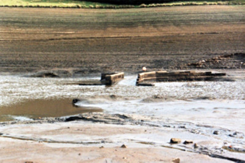
Above: I think this is the lost Errwood Bridge, rising above the waters of the reservoir during the drought of 1994. It’s taken from the Whaley Bridge Local History website.
Here’s the full text of the 1961 article;
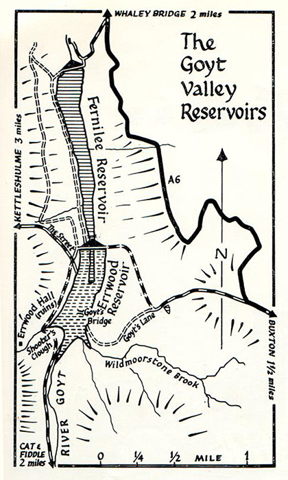
BUILDING OF THE Goyt Valley’s second reservoir, long since planned, is now to go ahead and it will take about four years to complete. Stockport and District Water Board has accepted, subject to Ministry approval, a £1,542,008 tender for the construction of Errwood Reservoir immediately to the south of the existing Fernilee Reservoir.
Another tender of £10,389 has also been accepted for the construction of a gauge on the Goyt at Taxal to measure compensation water provided by the board from its reservoirs for the river. The new reservoir will be formed behind an earth dam constructed just over a hundred yards south of the suspension footbridge over the tail of Fernilee. It will, therefore, truncate the present reservoir by nearly a quarter of a mile.
With a top water level of 917 feet above sea level, its capacity will be 935 million gallons, increasing the reliable yield from the valley by 2,700,000 gallons a day, and ensuring an adequate supply for the Board’s area until 1973.
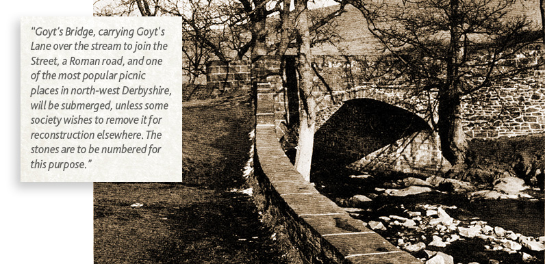
Goyt’s Bridge, carrying Goyt’s Lane over the stream to join the Street, a Roman road, and one of the most popular picnic places in north-west Derbyshire, will be submerged, unless some society wishes to remove it for reconstruction elsewhere. The stones are to be numbered for this purpose.
About 1,000 yards of the Street will disappear and a new road will skirt the water, crossing Shooter’s Clough a little more than half way up from Goyt’s Bridge to the ruins of Errwood Hall.
Another road will cross the top of the barrage, joining the Street on one side, and following the course of the old mineral railway up the hillside to join Goyt’s Lane on the east side of the valley. Goyt’s Lane is already metalled from Long Hill on the A6 to the junction.
The prospect of the new reservoir arouses mixed feelings. The disappearance of Goyt’s Bridge, the footpaths on either side of the stream down to Fernilee Reservoir, and the loss of a quarter of a mile of the lovely Shooter’s Clough will all be very sad. But at least much of the rhododendron and azalea-covered clough will be spared, and motorists will welcome the improved access from both sides of the main valley.
Cars will be able to cross further north, without intruding too far into the pedestrians’ preserve – the three miles of Goyt down to Taxal. Perhaps the most ominous thing about it all is the “adequate until 1973”. Four years to build, five years of adequacy, and then..?
Page update: Click here to view a better series of photos of Errwood Bridge emerging from the waters of Errwood Reservoir in 1984.